


In September - October 2008, the Sedalia - West Central Missouri Archaeological Society, abiding by Missouri and Federal Archaeological Laws regarding site excavations and archaeological surveys, and at the request of Professional Archaeologist, Gary Rex Walters, Ph.D., helped to excavate the Weigel Site in Morgan County, Missouri.

Weigel Site
Located in Stover, Morgan County, Missouri, owned by Mrs. Carol Sue Weigel - age 70. Excavated under the direction of Dr Gary Rex Walters of Triad Research Center. The Weigel Site is a prehistoric Late Archaic site, located on a ridge, containing Lithics, Lithic Tools, Lithic Scatter, and evidence of prehistoric Habitation. Gabriel Creek, an intermittent stream, runs just west of the Site.
Located in Stover, Morgan County, Missouri, owned by Mrs. Carol Sue Weigel - age 70. Excavated under the direction of Dr Gary Rex Walters of Triad Research Center. The Weigel Site is a prehistoric Late Archaic site, located on a ridge, containing Lithics, Lithic Tools, Lithic Scatter, and evidence of prehistoric Habitation. Gabriel Creek, an intermittent stream, runs just west of the Site.


Figure 1: Lamine Study Unit
(Lamine River Drainage Basin; Lamine River Watershed)
(Lamine River Drainage Basin; Lamine River Watershed)
Site Provenience: This prehistoric archaeological site was originally identified by Carol Sue Weigel of Stover Missouri; its present limits were subsequently defined by Gary Rex Walters. Under the direction of Walters, limited testing at the site was done near the site's center by members of the Sedalia - West Central missouri Archaeological Society, a Chapter of the Missouri Archaeological Society, in September and October of 2008. This Late Archaic lithic scatter and habitation site is located in Stover, MO, which is encompassed in the Lamine Study Unit (Lamine River Drainage Basin; Lamine River Watershed) (Figure 1). The site is located on a generally SW-NE ridge about 700 meters east of Gabriel creek, an intermittent stream.
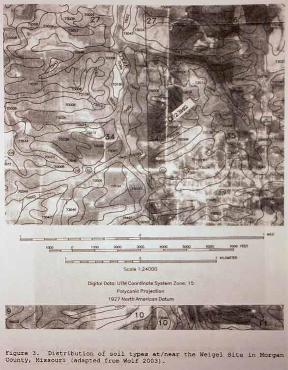
The soil at the site is currently classified as Union silt loam with 1-3 percent slopes (Wolf 2003) (Figure 3); this soil formed under woodland vegetation (Allgood and Persinger 1979). Data from the early nineteenth century suggest this area was in the native forest ecotone at that time (Schroeder 1981).
Figure 3: Distribution of soil types at / near the Weigel Site in Morgan County, Missouri (adapted from Wolf 2003).
Site Condition: When investigated in 2008 the ground cover at the site was sparse, eroded grass traversed by multi-track paths and surface visibility was generally between 25% and 75% (fair-good). The occurrence of small to medium sized, natural rocks on the surface indicates an undetermined amount of deflation has occurred there from past land modification activities including clearing, residential / kennel construction, use and erosion.
Investigative Methodology: The site was initially identified by Carol Sue Weigel, when she recovered sever cores, primary reduction flakes, Pre-forms (Figures 4, 5 and 6), Sedalia lanceolate-like bases (Figures 6 and 7), a Stone Square Stemmed-like base (Figure 8), and an Etley-like base (Figure 9) from an excavation to remove a stump from her front yard located on the south side of the residence. Gary Rex was eventually contacted and conducted a brief reconnaissance of the area and defined the presently defined limits of the site. Given the generally fair-good surface visibility there, the general area was examined by a pedestrian survey using direct surface observation techniques. . The area was traversed by a series of roughly parallel transects spaced about five meters apart. The ground surface along the transects was visually scanned for prehistoric artifacts / features; no cultural features were identified and no temporally diagnostic artifacts were recovered during the course of the pedestrian survey. Portable artifacts collected replicated the core and flake assemblage first identified by Weigel.
Subsequently limited testing was conducted aound Weigel's stump excavation by members of the Sedalia - West Central Missouri Archaeological Society under the direction of Gary Rex. The emphasis of this testing was to recover temporally diagnostic artifacts and establish the depositional integrity of the archaeological deposits.
In September and October of 2008, limited testing was conducted around Weigel's stump excavation by members of the Sedalia - West Central Missouri Archaeological Society under the direction of Gary Rex (Figure 10-15). Again, the emphasis of this testing was to recover temporally diagnostic artifacts and establish the depositional integrity of the archaeological deposits. Two Etley-like bases (Figure 16) and one Stone Square Stemmed-like base (Figure 17) were recovered from these excavations. In addition, two ovate, point / scraper / knife fragments were also recovered (Figure 18). Again, the recovered core / flake assemblage replicated those previously recovered from the site. Full analysis of all recovered artifacts is on-going.
The presence of natural rocks of varying sizes on the exposed surface of the site and in the uppermost level of the excavations indicate that between 24 and 36 inches of soil has been eroded or otherwise removed from the site area and that the recovered artifacts have been re-deposited (mostly by deflation) into the 2Btx soil zone which generally occurs between 30 and 53 inches below an undisturbed surface (Wolf 2003).
Site Function and Chronology: The prehistoric artifact assemblage recovered from the site suggests the area was used as a multi-function, long-term campsite, or series of campsites, at least during Late Archaic times (ca. 3000 - 500 BC). The lithic debitage recovered from the site indicate core reduction and primary flaking were the principal tasks carried out there; the point / scraper / knife fragments indicate faunal procurement / processing was also done there.
Site Integrity and NRHP Significance: The prehistoric artifact assemblage recovered from the site moderate to high density and low diversity and has a clearly defined Late Archaic Period cultural / chronological component. However, the extreme soil loss at the site and the re-deposition of artifacts into the 2Btx soil zone clearly demonstrates that the original depositional integrity of the site's cultural matrix has been destroyed by prior land modification activities. This lack of integrity negates the ability of the prehistoric Weigel site to contribute significant information toward more accurately reconstructing and better understanding local and regional prehistory. Thus, the Weigel site fails to meet the eligibility criteria for inclusion on the National Register of Historic Places.
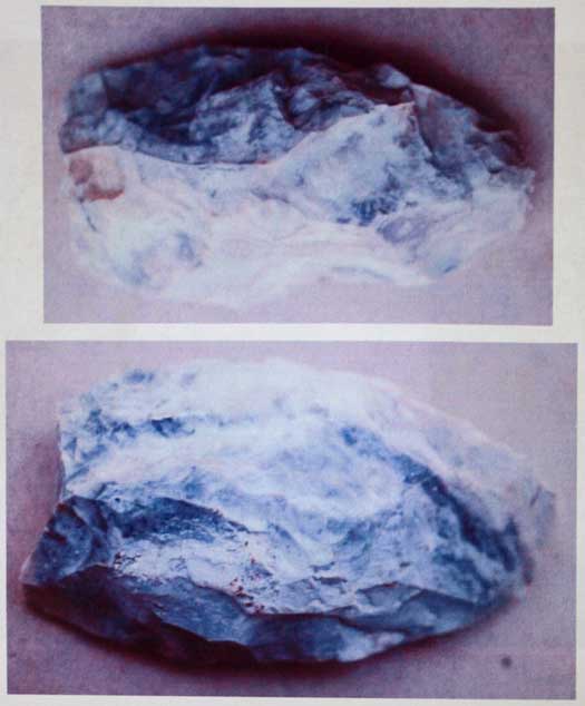
Figure 4: Early Stage Pre-forms recovered from the stump excavation by Weigel; these were apparently aborted because of structural flaws in the rock.
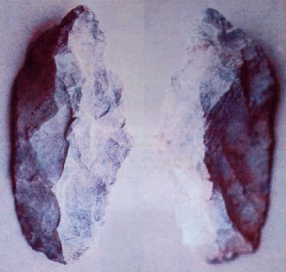
Figure 5: Middle Stage Pre-form recovered from the stump excavation by Weigel; this was apparently aborted because of structural flaws in the rock.
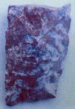
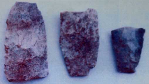
Figure 6: Late Stage Pre-forms recovered from the stump excavation by Weigel; these were apparently aborted because of structural flaws in the rock. The base of the example on the left is large enough to accommodate a Stone Square Stemmed- or Etley-like form. The two examples on the right may be representative of Sedalia Lanceolate-like forms (See Figure 7).
Figure 7: Sedalia Lanceolate-like, point / knife base recovered from the stump excavation by Weigel; this point / knife type generally dates
to the Late Archaic Period (3000 - 500 BC) (scale is actual size). This example may be a Late Stage Pre-form broken very late in the manufacturing stage.
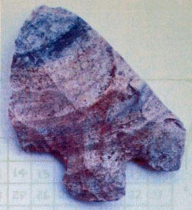
Figure 8: Stone Square Stemmed-like point / knife base recovered from the stump
excavation by Weigel; this point / knife type generally dates to the Late Archaic Period (3000 - 500 BC). This example may be a Late Stage Pre-form broken very late in the manufacturing stage.
(edge)
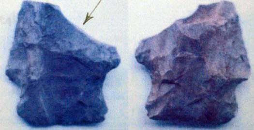
Re-tooled into a scraper.
-Hoyne
-Hoyne
Figure 9: Etley-like point / knife base recovered from the stump excavation by Weigel; this point / knife type generally dates to the Late Archaic Period (3000 - 500 BC). This example represents a finished form broken during its use process.
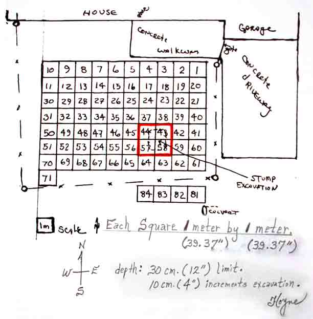
Figure 10: Sketch map of the excavation area at the Weigel Site.
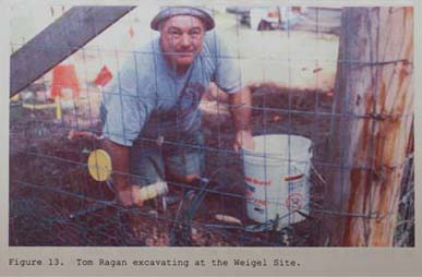

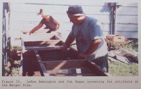

Figures 12-15: Some of the excavators at the Weigel Site.
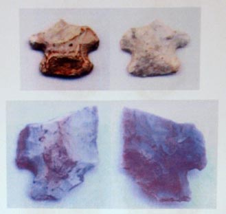
Figure 16: Etley-like point / knife bases recovered from the Weigel Site; top specimen is from Square # 57, bottom specimen is from Square # 59.
Figure 17: Etley stemmed
base, straight sided var.,point / knife base recovered from Square # 57.


Email Archaeologist Dr Gary Rex Walters directly at: garyrex@mas-sedalia.theartifactvault.com